1900s
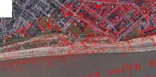
Coastal erosion (South beach, Lowestoft) 1906-2023 approx 200m!
Measuring from the current cliff-top edge to the east of All Saints Church (as was) to the low-water mark on a OS 25-inch map, revised in 1903 and published in 1905.
The lines in red are the old roads and buildings.
Added: 23 September, 2023
Thanks to Marion Hayes for an excellent photo from early 1900’s showing building work on the Town Hall. We had been struggling to find ANY front on old images for this historic building. Now it is pride of place on our stroll
Added: 23 September, 2023
extract from Lowestoft Journal - Saturday 04 October 1913
Added: 23 September, 2023